Contents
1.1 Purpose
of the Report
1.2 Structure
of the Report
2.1 Background
2.2 Marine
Construction Works Undertaken during Reporting Week
2.3 Status
of Environmental Approval Documents
3 Impact
Water Quality Monitoring Requirements
3.1 Monitoring
Locations
3.2 Monitoring
Parameters
3.3 Monitoring
Equipment and Methodology
4.1 Data
Collected During Reporting Period
4.2 Exceedances
During Reporting Period
5 Environmental
Non-CONFORMANCES
5.1 Summary
of Environmental Exceedance
5.2 Summary
of Environmental Non-compliance
5.3 Summary
of Environmental Complaint
5.4 Summary
of Environmental Summons and Prosecution
6.1 Key
Issues For The Coming Reporting Period
6.2 Monitoring
Schedule For The Coming Reporting
Period
LIST
OF TABLES
Table 2.1 Summary of Environmental Licensing, Notification, Permit and
Reporting Status
Table 3.1 Co-ordinates of Water Quality Impact Monitoring Stations in Zone A
Table 3.2 Co-ordinates of Water Quality Impact Monitoring Stations in Zone B
Table 3.3 Equipment Used during the Impact Water Quality Monitoring
Table 3.4 Monitoring Frequency and Parameters for Impact Monitoring in Zone A
and Zone B
Table 3.5 Action and Limit Levels of Water Quality for Zones A
Table 3.6 Action and Limit Levels for Water Quality for Zone B
Table 4.1 Summary of Exceedances
Occurring during the Reporting Week
Table 4.2 Exceedances of Action and Limit Levels on 8 October 2012
Table 4.3 Exceedances of Action and Limit Levels on 9 October 2012
Table 4.4 Exceedances of Action and Limit Levels on 10 October 2012
Table 4.5 Exceedances of Action and Limit Levels on 11 October 2012
Table 4.6 Exceedances of Action and Limit Levels on 13 October 2012
Table 4.7 Exceedances of Action and Limit Levels on 14 October 2012
LIST
OF ANNEXES
|
Annex A |
|
|
Annex B |
|
|
Annex C |
|
|
|
|
The submarine
cable installation works for the Asia
Submarine-cable Express (ASE) cable system were commenced on 8 October 2012. This is the First Weekly Impact Water Quality Monitoring Report presenting the impact water quality monitoring
conducted during the period from 8 October
2012 to 14 October 2012 in
accordance with the Monitoring and Audit Manual
(EM&A Manual).
Summary of
Construction Works Undertaken during the Reporting Period
During
the reporting period, submarine cable laying works in Zone A and B were
undertaken and had been largely completed by the end of the week.
Water Quality Monitoring
Seven monitoring events were scheduled
in the reporting period in Zone A and Zone B. Monitoring events at Zone A and Zone B
designated monitoring stations were generally performed on schedule.
Environmental
Non-conformance
Exceedances
of Action and Limit Levels were recorded during the reporting week. However, the exceedances
were considered to reflect natural background fluctuation rather than to be
caused by the Project.
No complaint
and summons/prosecution was received during the reporting week.
Future
Key Issues
The submarine
cable installation works will be conducted in Zone C and from Zone C eastward
to the boundary Hong Kong marine waters in the coming week. Impact
water quality monitoring will then be carried out in Zone C and cease once the cable installation barge
moves out Zone C or no cable laying works are undertaken within Zone C.
ERM-Hong Kong, Limited
(ERM) was appointed by NTT Com Asia (NTTCA) as the Environmental Team (ET) to
implement the Environmental Monitoring and Audit (EM&A) programme for the
installation of a telecommunication cable (Asia-Submarine-cable Express (ASE)) of
approximately 7,200 km in length, connecting Japan and Singapore with branches
to the Philippines, Hong Kong SAR (HKSAR) and Malaysia (thereinafter called the Project).
This is the First Weekly Impact Water Quality Monitoring Report, which summarises the results of
impact water quality monitoring as part of the EM&A programme during the
reporting period from 8
October to 14 October
2012.
The structure of the Report
is as follows:
Section
1 : Introduction
Provides details of the background,
purpose and report structure.
Section 2 : Project
Information
Summarises background and scope of the project, the
construction works undertaken and the status of Environmental Permits/Licenses during
the reporting period.
Section
3 : Water
Quality Monitoring Requirements
Summarises
the monitoring parameters, monitoring programmes, monitoring methodologies,
monitoring frequency, monitoring locations, Action and Limit Levels, and Event
Action Plan.
Section
4 : Monitoring
Results
Summarises the water quality
monitoring results obtained in the reporting period.
Section
5 : Environmental
Non-conformance
Summarises any monitoring exceedance, environmental
complaints and environmental summons within the reporting period.
Section
6 : Future
Key Issues
Summarises
the monitoring schedule for the next reporting period.
Section
7 : Conclusions
Presents the key findings
of the impact monitoring results.
NTT
Com Asia (NTTCA) proposes to install a telecommunication cable (Asia
Submarine-cable Express (ASE) cable) of approximately 7,200 km in length,
connecting Japan and Singapore with branches to the Philippines, Hong Kong SAR
(HKSAR) and Malaysia. NTTCA is responsible
for securing the approval to land the ASE cable in Tseung
Kwan O, Hong Kong SAR (HKSAR). The
proposed landing site will be at a new Beach Manhole (BMH) and ultimately
connect with a Data Centre in Tseung Kwan O (TKO)
Industrial Estate which is scheduled for completion in 2012. From Tseung
Kwan O, the cable will extend eastward approaching the Tathong
Channel. Near to Cape Collinson, the cable is approximately parallel to the Tathong Channel until north of Waglan
Island where the cable travels eastward to the boundary of HKSAR waters where
it enters the South China Sea. The
total length of cable in Hong Kong SAR waters is approximately 33.5 km. A map of the proposed cable route is
presented in Figure 2.1.
A
Project Profile (PP-452/2011) which includes an assessment of the potential
environmental impacts associated with the installation of the submarine
telecommunications cable system was prepared and submitted to the Environmental
Protection Department (EPD) under section 5. (1)(b)
and 5.(11) of the Environmental Impact Assessment Ordinance (EIAO) for the
application for Permission to apply directly for Environmental Permit
(EP). The Environmental Protection
Department, subsequently issued an Environmental Permit (EP- 433/2011).
Pursuant
to Condition 2.4 of the EP, an environmental monitoring and audit programme as
set out in the Environmental Monitoring and Audit Manual (EM&A Manual) is
required to be implemented. In
accordance with Section 2 of the EM&A Manual, impact monitoring of marine
water quality should be undertaken when the cable installation barge works in
Zone A, Zone B and Zone C.
Impact
monitoring started on 8 October 2012, when the cable laying works commenced in
Zone A. During the reporting
period, the impact monitoring was conducted on a daily basis as the cable
laying works proceeded in Zone A and Zone B. This Report therefore
presents the monitoring results from the monitoring stations in Zone A and Zone
B.
Cable
laying works in Zone A and Zone B were undertaken during the reporting week
from 8 October 2012 to 14 October 2012, and had been largely
completed by the end of the week.
A
summary of the relevant permits, licences and reports on environmental
protection for this Project is presented in Table
2.1.
Table 2.1 Summary of Environmental
Licensing, Notification, Permit and Reporting Status
|
Permit / Licence / Notification /
Report |
Reference |
Validity Period |
Remarks |
|
Environmental Permit |
EP 433/2011 |
Throughout the
construction and operation stages |
Granted on 20 December
2011 |
|
EM&A Manual |
- |
Throughout the
construction stage |
Revised EM&A Manual
submitted on 18 September 2012 |
|
Baseline Water Quality
Monitoring Report (Zone A) |
- |
Throughout the
construction period for Zone A |
Submitted on 19 September
2012 |
|
Baseline Water Quality
Monitoring Report (Zone B) |
- |
Throughout the
construction period for Zone B |
Submitted on 25 September
2012 |
|
Baseline Water Quality
Monitoring Report (Zone C) |
|
Throughout the
construction period for Zone C |
Submitted
on 1 October 2012 |
In accordance with the EM&A Manual, during the installation
of the cable in Zone A, water quality sampling was undertaken at the stations
situated around the cable laying works in Zone A. The locations of the sampling stations
within Zone A are shown in Figure 3.1.
�P E7
is the Impact Station located at Fat Tong Chau to
monitor the impacts of cable installation works on the coral communities in the
proximity;
�P E8
is an Impact Station to monitor the impacts of cable installation works on the
coral communities along Junk Bay �V South West;
�P E9
is an Impact Station to monitor the impacts of cable installation works on the
coral communities at Cape Collison (the Gradient
Station is not set due to the short distance of this Impact Station to nearby
proposed cable works which may affect the cable laying works);
�P F1
is an Impact Station to monitor the impacts of cable installation works on the
Tung Lung Chau Fish Culture Zone;
�P S1
is an Impact Station situated at the WSD Seawater Intake Point in Junk
Bay. It is located within 500 m
north of the cable alignment at Junk Bay and set up to monitor the effect of
cable laying works in the area;
�P S2
is an Impact Station to monitor the impacts of cable installation works on the
WSD Seawater Intake at Siu Sai
Wan;
�P S3
is an Impact Station to monitor the impacts of cable installation works on the
Pamela Youde Nethersole
Eastern Hospital Cooling Water Intake at Heng Fa Chuen;
�P G1
is a Gradient Station between S1 and the cable alignment;
�P G2
is a Gradient Station between S2 and the cable alignment;
�P G3
is a Gradient Station between F1 and the cable alignment; and
�P C1
is a Control Station (approximately 3 km from the proposed cable alignment) for
Zone A. It is not supposed to be
influenced by the cable laying works due to its remoteness to the construction
works.
The
co-ordinates of the above monitoring stations in Zone A are listed in Table 3.1.
Table 3.1 Co-ordinates of Water
Quality Impact Monitoring Stations in Zone A
|
Monitoring
Station |
Nature |
Easting |
Northing |
|
E7 |
Impact
Station (Coral Community) |
843779 |
814520 |
|
E8 |
Impact
Station (Coral Community) |
843111 |
815126 |
|
E9 |
Impact
Station (Coral Community) |
843557 |
811853 |
|
F1 |
Impact Station (Fish Culture Zone) |
847196 |
811056 |
|
S1 |
Impact Station (Seawater Intakes) |
847639 |
805900 |
|
S2 |
Impact Station (Seawater Intakes) |
849587 |
805696 |
|
S3 |
Impact Station (Seawater Intakes) |
845474 |
810605 |
|
G1 |
Gradient
Station |
845297 |
816282 |
|
G2 |
Gradient
Station |
844071 |
814784 |
|
G3 |
Gradient
Station |
846099 |
812826 |
|
C1 |
Control
Station |
842022 |
816547 |
In accordance with the EM&A Manual, during the installation
of the cable in Zone B, water quality sampling was undertaken at the stations
situated around the cable laying works in Zone B. The locations of the sampling stations
within Zone B are shown in Figure 3.2.
�P
B1
is an Impact Station to monitor the impacts of cable installation works on the
�P
B2
is an Impact Station to monitor the impacts of cable installation works on the
�P
B3
is an Impact Station to monitor the impacts of cable installation works on the Shek O Beach;
�P
E1
is an Impact Station to monitor impacts of cable installation works on
�P
E2
is an Impact Station to monitor the impacts of cable installation works on the
coral communities at Tung Lung Chau;
�P
E6
is an Impact Station to monitor the impacts of cable installation works on the
coral communities at Tai Long Pai (the Gradient
Station is not set due to the short distance of this Impact Station to nearby
proposed cable works which may affect the cable laying works);
�P
E9
is an Impact Station to monitor the impacts of cable installation works on the
coral communities at Cape Collison (the Gradient
Station is not set due to the short distance of this Impact Station to nearby
proposed cable works which may affect the cable laying works);
�P
F1
is an Impact Station to monitor the impacts of cable installation works on the
Tung Lung Chau Fish Culture Zone;
�P
G3
is a Gradient Station between F1 and the cable alignment;
�P
G4
is a Gradient Station between E2 and the cable alignment;
�P
G7
is a Gradient Station between E1 and the cable alignment; and
�P C2 is a Control Station
(approximately 3.4 km from the proposed cable alignment) for Zone B. It is not supposed to be influenced by
the cable laying works due to its remoteness to the construction works.
The
co-ordinates of the above monitoring stations in Zone B are listed in Table 3.2.
Table 3.2 Co-ordinates of Water
Quality Impact Monitoring Stations in Zone B
|
Monitoring
Station |
Nature |
Easting |
Northing |
|
B1 |
Impact
Station (Beach) |
843557 |
811853 |
|
B2 |
Impact
Station (Beach) |
844062 |
810369 |
|
B3 |
Impact
Station (Beach) |
843988 |
809902 |
|
E1 |
Impact Station (Marine Reserve) |
845474 |
810605 |
|
E2 |
Impact Station (Coral Communities) |
845203 |
815205 |
|
E6 |
Impact Station (Coral Communities) |
845321 |
816718 |
|
E9 |
Impact Station (Coral Communities) |
843557 |
811853 |
|
F1 |
Impact Station (Fish Culture Zone) |
847196 |
811056 |
|
G3 |
Gradient
Station |
846099 |
812826 |
|
G4 |
Gradient
Station |
846583 |
810809 |
|
G7 |
Gradient
Station |
845946 |
808583 |
|
C2 |
Control
Station |
849603 |
811528 |
The
impact water quality monitoring was conducted in accordance with the
requirements stated in the EM&A
Manual. Monitoring parameters
are presented as below.
Parameters measured in situ were:
�P
dissolved oxygen (DO) (%
saturation and mg L-1),
�P
temperature (�XC),
�P
turbidity (NTU), and
�P
salinity (‰).
The only parameter measured
in the laboratory was:
�P
suspended solids (SS) (mgL-1).
In addition to the water
quality parameters, other relevant data were measured and recorded in field
logs, including the location of the sampling stations, water depth, time,
weather conditions, sea conditions, special phenomena and work activities
undertaken around the monitoring and works area that may influence the monitoring
results.
Table 3.3 summaries
the equipment used for the impact water quality monitoring.
Table 3.3 Equipment
Used during the Impact Water Quality Monitoring
|
Equipment |
Model |
|
Global Positioning Device |
Garmin etrex 10 |
|
Water Depth Gauge |
Speedtech
Instrument SM-5A |
|
Water Sampling Equipment |
1510 Kemmerer Water Sampler |
|
Salinity, DO, Temperature Measuring Meter |
YSI Pro 2030 |
|
Current Velocity and Direction |
Flow Probe FP11 |
|
Turbidity Meter |
HACH Model 2100Q Turbid Meter |
In-situ
data and SS data were collected during the cable installation works from 07:00
to 23:00 on a daily basis. The
impact monitoring schedule for the reporting period is presented in Annex A.
Impact
monitoring at E7, E8, E9, F1, S1, S2, S3, G1, G2, G3 and C1 commenced when the
cable installation barge works were within Zone A. The sampling works ceased once the cable
barge was outside Zone A or no cable laying works were being undertaken within
Zone A.
Similarly,
impact monitoring at C2, G3, G4, G7, B1, B2, B3, E1, E2, E6, E9 and F1
commenced when the cable installation barge works were within Zone B. The sampling works ceased once the cable
barge was outside Zone B or no cable laying works were being undertaken within
Zone B.
Due to the weather
conditions and travelling time between stations, in-situ and SS measurements were taken at the impact monitoring
stations with approximately four-hour interval in Zone A and Zone B. The monitoring frequency and parameters
for Impact Monitoring are summarised in Table
3.4.
Table
3.4 Monitoring
Frequency and Parameters for Impact Monitoring in Zone A and Zone B
|
Zone |
Station Type |
Monitoring Station |
Monitoring Frequency |
Monitoring Parameter |
|
A |
Control |
C1 |
Daily
at ~4-hour interval while cable installation works were being undertaken in
Zone A |
Temperature,
Turbidity, Salinity, DO and SS |
|
Gradient |
G1, G2, G3 |
|||
|
Impact |
E7, E8, E9, F1, S1, S2, S3, |
|||
|
B |
Control |
C2 |
Daily
at ~4-hour interval while cable installation works were being undertaken in
Zone B |
Temperature,
Turbidity, Salinity, DO and SS |
|
Gradient |
G3, G4, G7 |
|||
|
Impact |
B1, B2, B3, E1, E2, E6, E9, F1 |
Duplicate samples were collected from each of the
monitoring events for in situ measurements and laboratory analysis.
Each station was sampled and measurements/ water
samples were taken at three depths, namely, 1 m below water surface, mid-depth
and 1 m above sea bed, except where the water depth less than 6 m, the
mid-depth station may be omitted.
For stations that are less than 3 m in depth, only the mid-depth sample
was taken.
For in situ measurements, duplicate readings were
made at each water depth at each station.
Duplicate water samples were collected at each water depth at each
station.
All
in situ monitoring instruments were
checked, calibrated and certified by a laboratory accredited under HOKLAS or
any other international accreditation scheme before use, and subsequently
re-calibrated at-monthly intervals throughout all stages of the water quality
monitoring. Responses of sensors
and electrodes were checked with certified standard solutions before each use.
For
the on-site calibration of field equipment, the BS 1427: 1993, Guide to Field and On-Site Test Methods for the Analysis
of Waters was observed. Sufficient
stocks of spare parts were maintained for replacements when necessary. Backup monitoring equipment was made
available.
Water
samples for SS measurements were collected in high density polythene bottles,
packed in ice (cooled to 4�X C without being frozen), and delivered to a HOKLAS
laboratory as soon as possible after collection.
Two
replicate samples were collected from each of the monitoring events for in situ measurement and lab analysis.
All laboratory work was carried
out in a HOKLAS accredited laboratory.
Water samples of about 1,000 mL were collected at the monitoring and
control stations for carrying out the laboratory determinations. The determination work started within
the next working day after collection of the water samples. The SS laboratory measurements were
provided within 2 days of the sampling event (48 hours). The analyses followed the standard
methods as described in APHA Standard Methods for the Examination of Water and Wastewater, 19th Edition, unless otherwise specified (APHA 2540D for SS).
The QA/QC details were in
accordance with requirements of HOKLAS or another internationally accredited
scheme (Annex
B)
The Action and Limit levels
for Zones A, which were established based on the results of Baseline Environmental Monitoring (Zone A),
are presented in Table 3.5.
Table 3.5 Action and Limit Levels of
Water Quality for Zones A
|
Parameter |
Action Level |
Limit Level |
|
SS in mgL-1 (Depth-averaged) (a)
(c) |
95%-ile of baseline data (6.27
mg L-1), or |
99%-ile of baseline data (6.40
mg L-1) , and |
|
20%
exceedance of value at any impact station compared with corresponding data
from control station |
30%
exceedance of value at any impact station compared with corresponding data
from control station |
|
|
DO in mgL-1
(b) |
Surface and Middle(d) 5%-ile of baseline data for surface and middle layer (4.36
mg L-1) |
Surface and Middle(d) 5mg/L
or 1%-ile of baseline for surface and middle layer (4.25
mg L-1) |
|
Bottom 5%-ile of baseline data for bottom layers (4.39 mg L-1) |
Bottom 2mg/L
or 1%-ile of baseline data for bottom layer (4.33 mg L-1) |
|
|
Turbidity in NTU
(Depth-averaged) (a) (c) |
95%-ile of baseline data (4.38
NTU), or |
99%-ile of baseline data (4.43
NTU), and |
|
20%
exceedance of value at any impact station compared with corresponding data
from control station |
30%
exceedance of value at any impact station compared with corresponding data
from control station |
|
|
Notes: a.
��Depth-averaged�� is calculated by taking
the arithmetic means of reading of all sampled depths. b.
For DO, non-compliance of the water quality
limits occurs when the monitoring result is lower than the limits. c.
For SS and turbidity, non-compliance of the
water quality limits occurs when monitoring result is higher than the limits. d.
The Action and Limit Level for DO for
surface and middle layer were calculated from the combined pool of baseline
surface layer data and baseline middle layer data. |
||
The
Action and Limit levels for Zones B, which were established based on the
results of Baseline Environmental
Monitoring (Zone B), are presented in Table
3.6.
Table 3.6 Action and Limit Levels
for Water Quality for Zone B
|
Parameter |
Action Level |
Limit Level |
|
SS in mgL-1 (Depth-averaged) (a)
(c) |
95%-ile of baseline data (4.09
mg L-1), or |
99%-ile of baseline data (4.60
mg L-1) , and |
|
20%
exceedance of value at any impact station compared with corresponding data
from control station |
30%
exceedance of value at any impact station compared with corresponding data
from control station |
|
|
DO in mgL-1
(b) |
Surface and Middle(d) 5%-ile of baseline data for surface and middle layer (4.72
mg L-1) |
Surface and Middle(d) 5mg/L
or 1%-ile of baseline for surface and middle layer (4.57
mg L-1) |
|
Bottom 5%-ile of baseline data for bottom layers (4.52 mg L-1) |
Bottom 2mg/L
or 1%-ile of baseline data for bottom layer (4.44 mg L-1) |
|
|
Turbidity in NTU
(Depth-averaged) (a) (c) |
95%-ile of baseline data (3.01
NTU), or |
99%-ile of baseline data (3.13
NTU), and |
|
20%
exceedance of value at any impact station compared with corresponding data
from control station |
30%
exceedance of value at any impact station compared with corresponding data
from control station |
|
|
Notes: e.
��Depth-averaged�� is calculated by taking
the arithmetic means of reading of all sampled depths. f.
For DO, non-compliance of the water quality
limits occurs when the monitoring result is lower than the limits. g.
For SS and turbidity, non-compliance of the
water quality limits occurs when monitoring result is higher than the limits. h.
The Action and Limit Level for DO for
surface and middle layer were calculated from the combined pool of baseline
surface layer data and baseline middle layer data. |
||
The Event and Action Plan
for water quality monitoring which was stipulated in the EM&A Manual is presented in Table
3.7.
Table
3.7 Event
Action Plan for Water Quality
Event |
Contractor |
|
Action
Level Exceedance |
Step 1
- repeat sampling event. Step
2 �V identify
source(s) of impact and confirm whether exceedance was due to the
construction works; Step
3 �V inform EPD,
AFCD and LCSD and confirm notification of the non-compliance in writing; Step
4 - discuss with
cable installation contractor the most appropriate method of reducing
suspended solids during cable installation (e.g. reduce cable laying
speed/volume of water used during installation). Step
5 - repeat
measurements after implementation of mitigation for confirmation of
compliance. Step
6 - if non compliance continues - increase measures in Step 4
and repeat measurements in Step 5.
If non compliance occurs a third time,
suspend cable laying operations. |
|
Limit Level
Exceedance |
Undertake Steps 1-5 immediately, if further non compliance continues at the Limit Level, suspend
cable laying operations until an effective solution is identified. |
A total of seven monitoring events were
scheduled between 8
October and 14 October
2012. Monitoring events at all designated
monitoring stations within Zone A and Zone B were generally performed on
schedule. No major activities
influencing the water quality were identified during the reporting period.
Continuous water sampling
was taken at the impact monitoring stations in Zone A and Zone B at
approximately 4-hour intervals (subject to the weather conditions and
travelling time between stations) on a daily basis. In general, the water quality of Zone A
and Zone B was stable throughout each sampling day though natural fluctuation
existed. Neither sudden drop in
dissolved oxygen concentrations nor sharp increase in turbidity levels and
suspended solid levels were observed on each monitoring day. The results of the impact monitoring and
their graphical presentations were included in Annex C.
Despite
relatively stable water quality, exceedances of the Action and Limit
Levels were recorded during the reporting week except 12 Oct 2012. A summary of stations where exceedances were recorded is presented in Table 4.1. Exceedances
with detailed information of location and time were presented in Annex C.
Table 4.1
Summary of Exceedances Occurring during the Reporting Week
|
Surface DO |
Middle DO |
Bottom DO |
Depth-averaged Turbidity |
Depth-averaged SS |
||||||
|
Date |
Exceedance
of |
|||||||||
|
Action
Level |
Limit
Level |
Action
Level |
Limit
Level |
Action
Level |
Limit
Level |
Action
Level |
Limit
Level |
Action
Level |
Limit
Level |
|
|
08/10 |
|
|
|
|
E9, S3 |
E9, S3 |
|
|
|
|
|
09/10 |
|
|
|
|
S1, S2, S3 |
S1 |
|
|
|
|
|
10/10 |
|
|
|
|
E9, S3 |
E9, S3 |
|
|
|
|
|
11/10 |
|
|
|
|
E9, S3 |
|
|
|
|
|
|
12/10 |
|
|
|
|
|
|
|
|
|
|
|
13/10 |
|
|
F1 |
|
|
|
E9, F1, B3 |
E9 |
E9, F1 |
E9 |
|
14/10 |
|
|
F1 |
|
|
|
E9, F1 |
E9 |
E9 |
E9 |
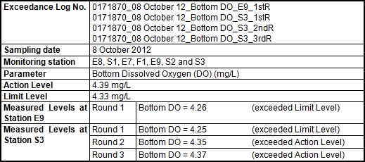
Exceedances of the Action and Limit
Levels in bottom DO were recorded at Stations E9 and S3 in the 1st,
2nd and 3rd sampling rounds on 8 October 2012 (Table 4.2).
According
to the daily barge operation report, there were some maintenance and repair
works carried out by the Contractor and the burial operation (ie jetting works) did not start until 17:00 of 08 October
2012. Jetting works were undertaken
between 17:00 �V 23:00 on the day.
As
stated above, jetting works for the Project were not being undertaken when the exceedances were recorded in the 1st and 2nd rounds of
marine water quality monitoring (ie 09:00 �V
15:04). Therefore, the exceedances of the Action/Limit levels at E9 and S3 in the
first two rounds are considered as representing natural background
fluctuations.
The exceedances of
the Action Level at S3 in the 3rd round of marine water quality
monitoring is marginal in nature, with merely 0.02 mg/L lower than the
corresponding Action Level value (ie 4.39 mg/L). When the sampling was carried out, the
current direction was westward.
Given the fact that the bottom DO value at Gradient Station G2 (4.78
mg/L), which is situated between the barge and S3, was within the Action Level,
the exceedance measured at the S3 was unlikely to be caused by the jetting
works but should be considered as an occasional case and representing natural
background levels during the time of monitoring.
Table 4.2 Exceedances
of Action and Limit Levels on 8 October
2012
Exceedances of the Action and Limit
Levels in bottom DO were recorded at Stations S1, S2 and S3 in all four
sampling rounds on 9 October 2012 (Table
4.3).
According
to the daily barge operation report, there were preparation and equipment
maintenance works carried out by the Contractor before the burial operation (ie jetting works) resumed at 11:30. All marine works stopped at
approximately 20:00 in the evening.
The actual time of jetting works on 09 Oct 2012 was between 11:30 to
20:00.
As stated above, jetting works were not being
undertaken when the exceedances were recorded in the
1st round and late stage of the 4th round of marine water
quality monitoring (ie in the periods of 07:00 �V
10:55 and 20:00 �V 23:05).
Therefore, the exceedances of the Action/Limit
levels at S1 in the 1st sampling round and S3 in the 4th
round are considered as representing natural background fluctuations rather
than a result of the cable installation works.
Despite the Action Level exceedance at S1 in
the 2nd sampling round, the bottom DO value (4.34 mg/L) was higher
than that measured at the same station in the 1st round (4.28 mg/L)
when jetting works had yet to start and was not expected to impose any
impact. The bottom DO at S1
continued to increase and was found to be compliant with the water quality
limit in the 3rd sampling round when jetting works resumed after
11:30 and were taking place at the time of sampling (11:40 - 11:55). Therefore the exceedance measured at the
S1 in the 2nd round was unlikely to be caused by the jetting works
but should be considered as representing natural background levels during the
time of monitoring.
The exceedance of the Action Level at S2 in
the 3rd round of marine water quality monitoring is an occasional
case that occurred only once among all four sampling rounds. The exceedance of the Action Level at S3
in the 3rd round is marginal in nature, with merely 0.03 mg/L lower
than the corresponding Action Level value (ie 4.39
mg/L). When the sampling at S2 and
S3 was carried out in the 3rd round, the current direction was westward. Given the fact that the bottom DO value
at Gradient Station G2 (4.71 mg/L), which is situated between the barge and
S2/S3, was within the Action Level, the exceedances
measured at S2 and S3 were unlikely to be caused by the jetting works but should
be considered as representing natural background levels during the time of
monitoring.
Table
4.3 Exceedances of Action and Limit Levels on 9 October 2012
Exceedances of the Action and Limit
Levels in bottom DO were recorded at Stations E9 and S3 in the 1st
and 2nd sampling rounds on 10 October 2012 (Table 4.4).
According
to the daily barge operation report, the Contractor did not conduct any jetting
works until 15:00 due to unfavourable weather conditions on that day. Between 13:00 �V 15:00, there were
preparation and equipment maintenance works carried out before the burial
operation (ie jetting works) resumed. Cable laying works stopped at
approximately 16:00 in the afternoon due to restriction
to cross the Tathong Channel until 17:00 as per
recommendation from the Marine Department.
The actual time of jetting works on 10 Oct 2012 was between 15:00 -
16:00.
As stated above, jetting works were not being
undertaken when the exceedances were recorded in the
1st round of marine water quality monitoring (ie
07:00 �V 11:01). Therefore, the exceedances of the Limit levels at E9 and S3 in the 1st
sampling round are considered as representing natural background fluctuations
rather than a result of the cable installation works
Despite the Action Level exceedance at S3 in
the 2nd sampling round, the bottom DO value (4.35 mg/L) was higher
than that measured at the same station in the 1st round (4.25 mg/L)
when jetting works had yet to start and was not expected to impose any
impact. The bottom DO at S3
continued to increase and was found to be compliant with the water quality
limit in the 3rd sampling round when jetting works resumed after
15:00 and were taking place at the time of sampling (15:05 - 19:03). Therefore the exceedance measured at the
S3 in the 2nd round was unlikely to be caused by the jetting works
but should be considered as representing natural background levels during the
time of monitoring.
Table
4.4 Exceedances of Action and Limit Levels on 10 October 2012
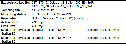
Exceedances of the Action Level in
bottom DO were recorded at Stations E9 and S3 only in the 3rd
sampling round on 11 October 2012 (Table
4.5).
According
to the daily barge operation report, there was preparation work carried out by
the Contractor before the burial operation (ie
jetting works) resumed at 10:45.
All marine works stopped at approximately 23:00 in the evening. The actual time of jetting works on 11
Oct 2012 was between 10:45 to 19:30 and 21:00 to 23:00.
The
exceedances of the Action Level at both E9 and S3 in
the 3rd sampling round are occasional. The bottom DO values at these two
stations increased and were found to be compliant with the water quality limit
in the 4th sampling round when jetting works were still being
conducted until 23:00. In addition,
jetting-related oxygen depletion is expected to be caused by the release of
suspended solids and its subsequent oxidative process. However in this case, depth-averaged
suspended solids levels at all monitoring stations were low and in compliance
with the Action and Limit Levels during all four water sampling rounds. Therefore the exceedances
were unlikely to be caused by the jetting works but should be considered as
reflecting natural background fluctuations during the time of monitoring.
Table
4.5 Exceedances of Action and Limit Levels on 11 October 2012
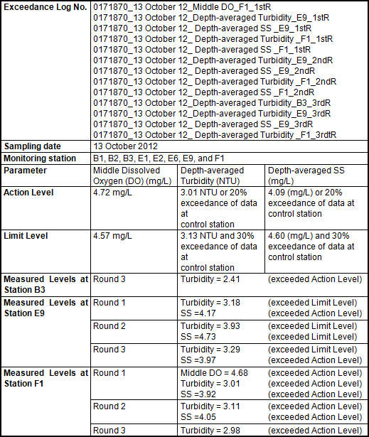
Due
to technical problems, impact water quality monitoring in Zone B started around
11:00 on 13 Oct 2012. As such, a
total of three rounds of water sampling were carried out for the day. Exceedances of
the Action and Limit Levels in middle DO, depth-averaged Turbidity and
depth-averaged SS were recorded at Stations B3, E9 and F1 in all three sampling
rounds (Table 4.6).
According
to the daily barge operation report, there were some preparations works carried
out by the Contractor before burial operation on the day. The burial operation (ie jetting works) was conducted between 10:30 to 12:00 and
13:30 to 16:30 on 13 October 2012.
As stated above, jetting works were not being
undertaken when the exceedance in Depth-averaged Turbidity was recorded at B3 (22:00
- 22:15) in the 3rd round of marine water quality monitoring. Therefore, the exceedance of the Action
Level at B3 is considered as representing natural background fluctuations.
Impact Stations E9 and F1 are located in the
north, far away from the cable installation barge. It should be noted that the average
values of depth-averaged Turbidity and depth-averaged SS at E9 (Turbidity =
3.68 NTU; SS = 4.29 mg/L) and F1 (Turbidity = 3.03 NTU; SS = 3.78 mg/L) on 13
October 2012 are actually of the similar magnitudes of their corresponding
values (averaged values of 8 �V 11 October 2012 for E9: Turbidity = 4.00 NTU, SS
=4.61 mg/L; averaged values of 8 �V 11 October 2012 for F1: Turbidity = 3.66
NTU, SS = 4.13 mg/L) in the previous dates or even better. When the sampling was carried out in the
first round, the current direction was eastward. Given the fact that values of all water
quality parameters at the Gradient Station (ie G4)
and Impact Station (ie E2) in the eastern vicinity of
the barge were measured to be within the corresponding Action Levels, the exceedances in middle DO, depth-averaged Turbidity and
depth-averaged SS at E9 and F1 in the 1st sampling round, as well as
later in the 2nd (18:44 �V 19:00 for E9 and 18:03 �V 18:17 for F1) and
3rd (19:02 - 19:18 for E9 and 19:44 �V 19:59 for F1) rounds when
jetting works ceased, were unlikely to be caused by the jetting works but
should be considered as representing natural background levels during the time
of monitoring.
Table
4.6 Exceedances of Action and Limit Levels on 13 October 2012
Exceedances
of the Action and Limit Levels in middle DO, depth-averaged Turbidity and
depth-averaged SS were recorded at Stations E9 and F1 in all four sampling
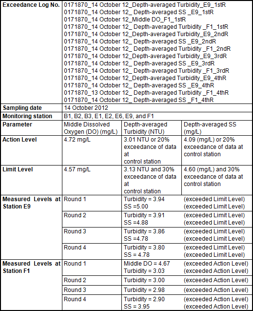
rounds on 14 October 2012 (Table 4.7). According to the daily barge operation
report, the burial operation (ie jetting works) was
conducted between 10:00 and 16:00 on the day.
Impact
Stations E9 and F1 are located in the north, far away from the cable
installation barge. It should be
noted that the average values of depth-averaged Turbidity and depth-averaged SS
at E9 (Turbidity = 3.87 NTU; SS = 4.86 mg/L) and F1 (Turbidity = 2.98 NTU; SS
=4.00 mg/L) on 13 October 2012 are actually of the similar magnitudes of their
corresponding values (averaged values of 8 �V 11 October 2012 for E9: Turbidity
= 4.00 NTU, SS =4.61 mg/L; averaged values of 8 �V 11 October 2012 for F1:
Turbidity = 3.66 NTU, SS = 4.13 mg/L) in the previous dates or even
better. Between these two stations
and the cable installation barge, there are several Gradient Stations (ie G3 and G4) and Impact Stations (ie
E2, E6 and B1), which are located in the middle and therefore more susceptible
to the impact of the Project. But exceedances of Action and Limit Levels in all water quality
parameters were recorded at none of these stations. The fact demonstrates the exceedances in middle DO, depth-averaged Turbidity and
depth-averaged SS at the E9 and F1 in the 1st and 2nd
sampling rounds, as well as later in the 3rd (15:05 �V 19:02) and 4th
(19:05 �V 23:04) rounds of marine water quality monitoring when jetting works
ceased, were unlikely to be caused by the jetting works but should be
considered as representing natural background levels during the time of
monitoring.
Table
4.7 Exceedances of Action and Limit Levels on 14 October 2012
Exceedances of the Action and Limit
Levels were recorded during the reporting period. The Event and Action Plan for the
identified exceedances were implemented and followed
the procedures as stipulated in the EM&A
Manual and Table 3.7. It was concluded that the exceedances were considered to reflect natural background
fluctuation rather than to be caused by the Project (See Section 4.2 for details).
No non-compliance events
were recorded during the reporting period.
No complaints were received
during the reporting period.
No summons or prosecution
on environmental matters were received during the reporting period.
The
cable installation works will be conducted in Zone C and from Zone C eastward
to the boundary Hong Kong marine waters.
Impact water quality
monitoring will be carried out in Zone C and will cease once the
cable installation barge moves out Zone C or no cable laying works are
undertaken within Zone C.
This Weekly Impact
Monitoring Report presents the results of impact water quality monitoring
undertaken in Zone A and Zone B during the period from 8 October to 14 October 2012
in accordance with the EM&A Manual
and the requirements under Environmental Permit (EP - 433/2011).
Water quality of Zone A and
Zone B was generally stable throughout the sampling period. Neither sudden drop in dissolved oxygen
concentrations nor sharp increase in turbidity levels and suspended solid
levels were observed. Exceedances of Action and Limit Levels were recorded during
the reporting week, but they were considered to reflect natural background
fluctuation rather than to be caused by the Project.
It is concluded that no
deterioration of water quality was observed and hence the effect of the Project
on water quality is considered to be negligible.